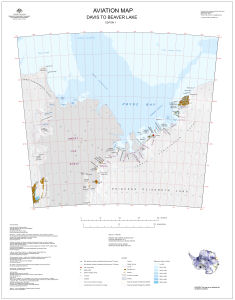
Map 13974: Aviation Map: Davis to Beaver Lake
Map details
| Map Number | 13974 |
| Title | Aviation Map: Davis to Beaver Lake |
| Edition | 1 |
| Scale | 1 : 1 000 000 |
| Publication date | December 2011 |
| Publisher |
Australian Antarctic Division (Australia)
|
| Spatial coverage |
( 68.0000° -67.0000°)
,
( 80.0000° -67.0000°)
,
( 80.0000° -71.0000°)
( 68.0000° -71.0000°) |
| Projection | Lambert Conformal Conic |
| Physical size | 77.2 x 60 cm |
| Keywords | Lars Christensen Coast , Ingrid Christensen Coast , Amery Ice Shelf , Publications Ice Shelf , Vestfold Hills , Larsemann Hills , Survey Marks , Topographic |
Downloads
This is a digital map available for downloading.
Map Lists
This map belongs to the following lists. Use the link on the list to see all maps belonging to that list
Additional Information
| Horizontal datum | WGS84 |
| Vertical datum | Mean sea level |
| Vertical unit | Metres |
| Nomenclature | Australian Antarctic Gazetteer |
Preview