Map 13987: Davis : Local Area
Map details
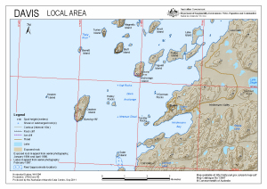
| Map Number | 13987 |
| Title | Davis : Local Area |
| Edition | 1 |
| Scale | 1 : 40 000 |
| Publication date | September 2011 |
| Publisher | - |
| Spatial coverage |
( 77.7928° -68.5419°)
,
( 78.0622° -68.5419°)
,
( 78.0622° -68.6019°)
( 77.7928° -68.6019°) |
| Projection | Universal Transverse Mercator |
| Physical size | 21 x 29.7 cm A4 |
| Keywords | Heidemann Valley , Law Cairn , Thala Rock , Krat Rocks , Hobby Rocks , Newman Shoal , Torckler Rocks , O'gorman Rocks , Lake Island , Flutter Island , Trigwell Island , Anchorage Island , Boyd Island , Bluff Island , Magnetic Island , Turner Island , Barratt Island , Keuken Island |
Downloads
This is a digital map available for downloading.
Map Lists
This map belongs to the following lists. Use the link on the list to see all maps belonging to that list
Additional Information
| Horizontal datum | WGS84 |
| Vertical datum | Mean sea level |
| Nomenclature | Australian Antarctic Gazetteer |
Preview