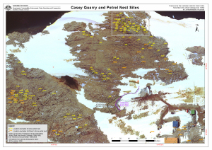
Map 13992: Casey Quarry and Petrel Nest Sites
Map details
| Map Number | 13992 |
| Title | Casey Quarry and Petrel Nest Sites |
| Edition | - |
| Scale | 1 : 1187 |
| Publication date | November 2011 |
| Publisher |
Australian Antarctic Division (Australia)
|
| Spatial coverage |
(110.5142° -66.2794°)
,
(110.5246° -66.2794°)
,
(110.5246° -66.2822°)
(110.5142° -66.2822°) |
| Projection | Universal Transverse Mercator |
| Physical size | 29.7 x 42 cm A3 |
| Notes | See also map number 13993 'Reeve Hill Snow Petrel Nest Sites'. |
| Alternative title | Wilson's storm petrel, snow petrel |
| Keywords | - |
Downloads
This is a digital map available for downloading.
Map Lists
No maps lists available.
Additional Information
| Horizontal datum | WGS84 |
Preview