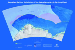
Map 14001: Australia's Maritime Jurisdiction off the Australian Antarctic Territory (West)
Map details
| Map Number | 14001 |
| Title | Australia's Maritime Jurisdiction off the Australian Antarctic Territory (West) |
| Edition | 1 |
| Scale | 1 : 2 000 000 |
| Publication date | 2010 |
| Publisher |
Geoscience Australia (Australia)
|
| Spatial coverage |
( 38.0000° -59.5000°)
,
( 84.0000° -59.5000°)
,
( 84.0000° -70.0000°)
( 38.0000° -70.0000°) |
| Projection | Lambert Conformal Conic |
| Physical size | 79 x 118 cm |
| Reference | GeoCat 69789 |
| Keywords | Maritime Jurisdiction , Australian Antarctic Basin , Enderby Basin , Southern Kerguelen Plateau , Cape Omega , Cape Hinode , Tange Promontory , Sakellan Peninsula , White Island , Cape Batterbee , Cape Borley , Cape Boothby , Ryrie Rock , Cape Fletcher , Cape Rouse , Cape Darnley , Fram Bank , Australia's Territorial Sea , Australia's Contiguous Zone Limit , Australia's Exclusive Economic Zone Limit , Geocat 69789 |
Downloads
This is a digital map available for downloading.
Map Lists
This map belongs to the following lists. Use the link on the list to see all maps belonging to that list
Additional Information
| Horizontal datum | WGS84 |
| Nomenclature | Australian Antarctic Gazetteer |
Preview