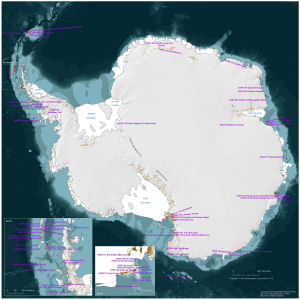
Map 14032: Locations of Antarctic Specially Protected Areas
Map details
| Map Number | 14032 |
| Title | Locations of Antarctic Specially Protected Areas |
| Edition | 1 |
| Scale | 1 : 10 550 000 |
| Publication date | May 2012 |
| Publisher |
Australian Antarctic Division (Australia)
|
| Spatial coverage |
(-180.0000° -53.8667°)
,
(180.0000° -53.8667°)
,
(180.0000° -90.0000°)
(-180.0000° -90.0000°) |
| Projection | Polar Stereographic |
| Physical size | 54.6 x 54.6 cm |
| Notes |
This map is to be included in a poster prepared by the Australian Antarctic Division for the 2012 Antarctic Treaty Consultative Meeting. The Antarctica Peninsula inset scale is 1: 3500000 and the Ross Sea inset scale is 1:2000000. |
| Keywords | - |
Downloads
This is a digital map available for downloading.
Map Lists
This map belongs to the following lists. Use the link on the list to see all maps belonging to that list
Additional Information
| Horizontal datum | WGS84 |
Preview