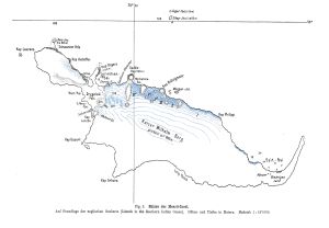
Map 14036: Skizze der Heard-Insel
Map details
| Map Number | 14036 |
| Title | Skizze der Heard-Insel |
| Edition | - |
| Scale | 1 : 187 600 |
| Publication date | 1908 |
| Publisher |
Germany
|
| Spatial coverage |
( 73.0000° -53.0000°)
,
( 74.0000° -53.0000°)
,
( 74.0000° -53.2500°)
( 73.0000° -53.2500°) |
| Projection | - |
| Physical size | 26.5 x 34.5 cm |
| Notes | Map published in the Deutsche Sudpolar Expedition 1901-03, Band 2, Heft 3, p. 233 (Berlin 1908) held in the Special Collection, Antarctic Division Library |
| Keywords | Heard Island , Deutsche Sudpolar Expedition 1901-03 , German South Polar Expedition 1901-03 , Kaiser Wilhelm Berg , Dryglaski Fels , Historical |
Downloads
This is a hard copy map that has been scanned. See information about obtaining copies of hard copy maps.
Map Lists
No maps lists available.
Additional Information
Preview