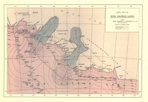
Map 14047: A.A.E. [Australasian Antarctic Expedition] 1911-14
King George Land
Map details
| Map Number | 14047 |
| Title | A.A.E. [Australasian Antarctic Expedition] 1911-14 King George Land |
| Edition | 1 |
| Scale | Not Entered |
| Publication date | 1914 |
| Publisher |
Australia
|
| Spatial coverage |
(142.0000° -66.4167°)
,
(153.0000° -66.4167°)
,
(153.0000° -69.1667°)
(142.0000° -69.1667°) |
| Projection | - |
| Physical size | 27.5 x 39.5 cm |
| Notes | Includes the sledge tracks of the Far-eastern party, Eastern coastal party and Southern party |
| Keywords | King George V Land , Eastern Sledging Parties , Mertz Glacier , Ninnis Glacier , Adelie Land , King George V Land , Sledge Tracks , Far-Eastern Party , Eastern Coastal Party , Southern Party |
Downloads
This is a hard copy map that has been scanned. See information about obtaining copies of hard copy maps.
Map Lists
This map belongs to the following lists. Use the link on the list to see all maps belonging to that list
Additional Information
Preview