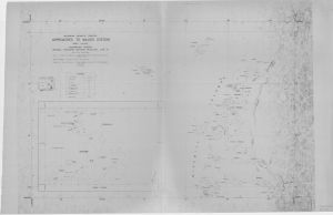
Map 14143: Approaches to Wilkes Station
Map details
| Map Number | 14143 |
| Title | Approaches to Wilkes Station |
| Edition | 1 |
| Scale | 1 : 50 000 |
| Publication date | July 1962 |
| Publisher |
Department of National Development, Division of National Mapping (Australia)
|
| Spatial coverage |
(109.7167° -66.1500°)
,
(110.7667° -66.1500°)
,
(110.7667° -66.4333°)
(109.7167° -66.4333°) |
| Projection | Universal Transverse Mercator |
| Physical size | 76 x 110 cm |
| Notes | Compiled by Division of National Mapping from ANARE vertical and oblique air photography, ANARE and US triangulation and hydrographic surveys to 1962. Soundings in fathoms. Inset plan: Newcombe Bay and Wilkes Station (1:12500). |
| Reference | NMP/62/38 |
| Keywords | NMP/62/38 , Approaches To Wilkes Station , Newcomb Bay , Survey Marks |
Downloads
This is a hard copy map that has been scanned. See information about obtaining copies of hard copy maps.
Map Lists
No maps lists available.
Additional Information
Preview