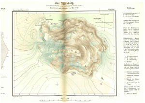
Map 14157: Der Gaussberg
Map details
| Map Number | 14157 |
| Title | Der Gaussberg |
| Edition | 1 |
| Scale | 1 : 7500 |
| Publication date | 1921 |
| Publisher |
Verlag Georg Reimer (Germany)
|
| Spatial coverage |
( 89.1589° -66.7983°)
,
( 89.2153° -66.7983°)
,
( 89.2153° -66.8133°)
( 89.1589° -66.8133°) |
| Projection | Not Given |
| Physical size | 25 x 30 cm |
| Notes |
German Expedition 1901-03
Nach den Aufnahmen von E. v. Drygalski und H. Gazert konstruiert und gezeichnet von Max Groll Published in Deutsche Sudpolar-Expedition 1901-3 Band 2, Tafel 1 |
| Alternative title | Gaussberg |
| Keywords | Gaussberg , Drygalski , German South Polar Expedition 1901-03 , Deutsche Sudpolar-Expedition 1901-3 , Survey Marks , Historical |
Downloads
No downloads available.
Map Lists
No maps lists available.
Additional Information
Preview