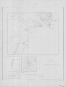
Map 14175: Sketch map of A.N.A.R.E. station area, Macquarie Island
Map details
| Map Number | 14175 |
| Title | Sketch map of A.N.A.R.E. station area, Macquarie Island |
| Edition | 1 |
| Scale | 1 : 2400 |
| Publication date | 1950 |
| Publisher |
Bureau of Mineral Resources, Geology and Geophysics, Department of National Development, Canberra (Australia)
|
| Spatial coverage |
(158.9325° -54.4969°)
,
(158.9456° -54.4969°)
,
(158.9456° -54.5033°)
(158.9325° -54.5033°) |
| Projection | Not Given |
| Physical size | 79.5 x 59.5 cm |
| Notes |
The map shows the position of the tide gauge in 1950. It includes two locality diagrams showing the position of the A.N.A.R.E. station on Macquarie Island and showing the location of Macquarie Island in the Southern Ocean. |
| Keywords | Anare Station Area 1950 , Tide Gauge , Seismological Observatory , Magnetic Stations , Survey Marks , Historical |
Downloads
This is a hard copy map that has been scanned. See information about obtaining copies of hard copy maps.
- A print file (PDF)
- A LZW compressed TIFF
- National Library of Australia Bib ID 4493223 (External site)
Map Lists
No maps lists available.
Additional Information
| Horizontal datum | Astro fix |
| Vertical datum | 1950 MSL |
Preview