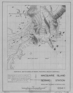
Map 14222: Macquarie Island Seismic Station
Map details
| Map Number | 14222 |
| Title | Macquarie Island Seismic Station |
| Edition | 1 |
| Scale | 1 : 950 |
| Publication date | January 1949 |
| Publisher |
Australia
|
| Spatial coverage |
(158.9350° -54.4881°)
,
(158.9444° -54.4881°)
,
(158.9444° -54.5017°)
(158.9350° -54.5017°) |
| Projection | - |
| Physical size | 49 x 38 cm |
| Notes | Initial map to assist in station siting. |
| Reference | G54-1 |
| Keywords | Buckles Bay , Blake , Bmr , Station Siting , Bureau Of Mineral Resources And Geophysics , Wireless Hill , Topographic |
Downloads
This is a hard copy map that has been scanned. See information about obtaining copies of hard copy maps.
Map Lists
No maps lists available.
Additional Information
| Horizontal datum | Datum by Blake |
| Vertical datum | MSL by AAE |
Preview