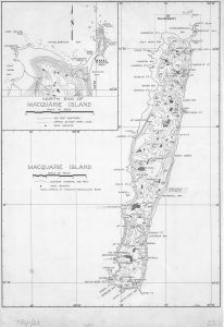
Map 14224: Macquarie Island (with inset of North End of Macquarie Island)
Map details
| Map Number | 14224 |
| Title | Macquarie Island (with inset of North End of Macquarie Island) |
| Edition | 1 |
| Scale | 1 : 63 360 |
| Publication date | January 1967 |
| Publisher |
Australia
|
| Spatial coverage |
(158.7333° -54.4583°)
,
(158.9750° -54.4583°)
,
(158.9750° -54.7972°)
(158.7333° -54.7972°) |
| Projection | - |
| Physical size | 75 x 51 cm |
| Notes | Inset showing North Head and northern end of Plateau |
| Reference | 786/1/23 |
| Keywords | Macquarie Island , Names , Topographic |
Downloads
This is a hard copy map that has been scanned. See information about obtaining copies of hard copy maps.
Map Lists
No maps lists available.
Additional Information
| Vertical datum | MSL |
| Nomenclature | Names approved by Tasmanian Nomenclature Board |
Preview