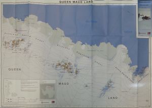
Map 14228: Queen Maud Land (Prototype map)
Map details
| Map Number | 14228 |
| Title | Queen Maud Land (Prototype map) |
| Edition | 1 |
| Scale | 1 : 1 000 000 |
| Publication date | December 2012 |
| Publisher |
National Geographic Institute of Belgium (Belgium)
|
| Spatial coverage |
( 7.8000° -68.0000°)
,
( 45.4667° -68.0000°)
,
( 45.4667° -76.1667°)
( 7.8000° -76.1667°) |
| Projection | Polar Stereographic |
| Physical size | 85 x 123 cm |
| Notes | This Belgium prototype map has been superseded by the Air Operations Planning Map series. See map numbers 14581 and 14621. |
| Keywords | Queen Maud Land , Princess Ragnhild Coast , Prince Harald Coast , SØR Rondane , Princess Elizabeth , Belgica , Mizuho Plateau , Riiser Larsen Peninsula , Syowa , Maitri , Novolazarevskaya , Erskine Ice Port , Jodel Iceport |
Downloads
No downloads available.
This is a hard copy map. See information about obtaining copies of hard copy maps.
Map Lists
No maps lists available.
Additional Information
| Horizontal datum | WGS84 |
| Vertical datum | MSL |
| Nomenclature | Scar CGA |
Preview