Map 14251: Mawson's Huts, Cape Denison
Map A
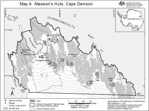
Map details
| Map Number | 14251 |
| Title | Mawson's Huts, Cape Denison Map A |
| Edition | 2 |
| Previous edition | [Previous edition : 1] |
| Scale | 1 : 10 000 |
| Publication date | December 2013 |
| Publisher |
Australian Antarctic Division (Australia)
|
| Spatial coverage |
(142.6506° -67.0036°)
,
(142.6908° -67.0036°)
,
(142.6908° -67.0131°)
(142.6506° -67.0131°) |
| Projection | Universal Transverse Mercator |
| Physical size | 15 x 20 cm |
| Reference | Management Plan for Antarctic Specially Protected Area |
| Keywords | Mawson's Huts , Cape Denison , Commonwealth Bay , Antarctic Specially Protected Area , Historic Site , Visual Protection Zone |
Downloads
This is a digital map available for downloading.
Map Lists
This map belongs to the following lists. Use the link on the list to see all maps belonging to that list
- Cape Denison / Commonwealth Bay
- Antarctic Specially Protected Areas and Antarctic Specially Managed Areas maps
Additional Information
| Horizontal datum | WGS84 |
| Vertical datum | Mean Sea Level |
Preview