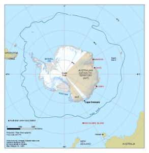
Map 14255: Location of Cape Denison, Antarctica
Map details
| Map Number | 14255 |
| Title | Location of Cape Denison, Antarctica |
| Edition | 1 |
| Scale | 1 : 54 000 000 |
| Publication date | September 2013 |
| Publisher |
Australian Antarctic Division (Australia)
|
| Spatial coverage |
(-180.0000° -30.0000°)
,
(180.0000° -30.0000°)
,
(180.0000° -90.0000°)
(-180.0000° -90.0000°) |
| Projection | Polar Stereographic |
| Physical size | 22.5 x 22 cm |
| Notes |
The map was produced for the Mawson’s Huts Foundation. The coastline of Antarctica is from the Antarctic Digital Database version 6 © Scientific Committee on Antarctic Research 1993-2013. The Antarctic Polar Front is data described in Orsi, A. H., Whitworth III, T., and Nowlin, W. D. (1995), On the meridional extent and fronts of the Antarctic Circumpolar Current. Deep-Sea Research I, 42(5), 641-673. |
| Keywords | Australian Antarctic Territory , Casey , Davis , Mawson , Macquarie Island , Polar Front , New Zealand |
Downloads
This is a digital map available for downloading.
Map Lists
This map belongs to the following lists. Use the link on the list to see all maps belonging to that list
Additional Information
Preview