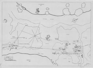
Map 14276: ANARE Macquarie Island
Plan of campsite
Map details
| Map Number | 14276 |
| Title | ANARE Macquarie Island Plan of campsite |
| Edition | - |
| Scale | Not Entered |
| Publication date | 1948 |
| Publisher | - |
| Spatial coverage |
(158.9333° -54.4969°)
,
(158.9417° -54.4969°)
,
(158.9417° -54.5000°)
(158.9333° -54.5000°) |
| Projection | - |
| Physical size | 39.3 x 54.3 cm |
| Notes |
The plan was drawn by Geoff Mottershead, Radio Supervisor with the ANARE wintering party at Macquarie Island in 1948, the year that the scientific station on the island was established. No publication date is given on the plan. It is assumed in this Map Catalogue entry to be 1948. |
| Keywords | 1948 , Station , Mottershead |
Downloads
This is a hard copy map that has been scanned. See information about obtaining copies of hard copy maps.
Map Lists
This map belongs to the following lists. Use the link on the list to see all maps belonging to that list
Additional Information
Preview