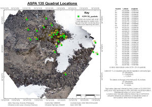
Map 14450: ASPA 135 Quadrat Locations
Map details
| Map Number | 14450 |
| Title | ASPA 135 Quadrat Locations |
| Edition | 1 |
| Scale | 1 : 400 |
| Publication date | May 2015 |
| Publisher |
The University of Wollongong (Australia)
|
| Spatial coverage |
(110.5375° -66.2819°)
,
(110.5398° -66.2819°)
,
(110.5398° -66.2827°)
(110.5375° -66.2827°) |
| Projection | Universal Transverse Mercator |
| Physical size | 29.7 x 42 cm A3 |
| Notes |
This map shows the locations of quadrats used for long term monitoring of vegetation in Antarctic Specially Protected Area (ASPA) 135 at Bailey Peninsula, Windmill Islands, Antarctica. The quadrats were established in 2002/03 under AAS Project 1313 and have been monitored at approximately five yearly intervals under this project and the subsequent AAS Project 4036 (Chief Investigator: Professor Sharon Robinson, University of Wollongong). The data are used for reporting on State of Environment Indicator 72. The quadrat locations are marked in the field with small metal tags glued to nearby rocks. Please avoid disturbing this area. |
| Keywords | Antarctic Specially Protected Area , Bailey Peninsula |
Downloads
Map Lists
This map belongs to the following lists. Use the link on the list to see all maps belonging to that list
Additional Information
| Horizontal datum | WGS84 |
Preview