Map 14456: Mawson: Buildings and Structures
Map details
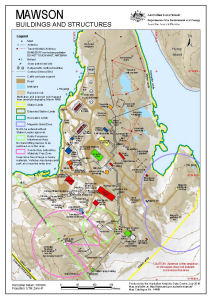
| Map Number | 14456 |
| Title | Mawson: Buildings and Structures |
| Edition | 9 (Out of Date) |
| Previous edition | [Previous edition : 8] |
| Next Edition | [Next Edition : 10] |
| Scale | 1 : 3000 |
| Publication date | July 2016 |
| Publisher |
Australian Antarctic Division (Australia)
|
| Spatial coverage |
( 62.8681° -67.5989°)
,
( 62.8808° -67.5989°)
,
( 62.8808° -67.6054°)
( 62.8681° -67.6054°) |
| Projection | Universal Transverse Mercator |
| Physical size | 29.7 x 21 cm A4 |
| Notes |
© Commonwealth of Australia 2016 . The locations of snow petrel nest sites shown on this map are from a survey by Frederique Olivier as described by the metadata record 'A GIS dataset of Snow Petrel nests mapped in the Mawson region during the 2004-2005 season'. |
| Keywords | Station Limits , Magnetic Quiet Zone , Radio Frequency Interference Area , Cosmic Ray Laboratory Materials Free Zone |
Downloads
This is a digital map available for downloading.
Map Lists
No maps lists available.
Additional Information
| Horizontal datum | WGS84 |
| Vertical datum | Mean sea level |
| Vertical unit | Metres |
Preview