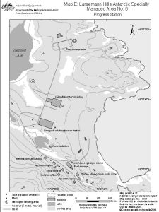
Map 14658: Larsemann Hills Antarctic Specially Managed Area No.6
Map E: Progress Station
Map details
| Map Number | 14658 |
| Title | Larsemann Hills Antarctic Specially Managed Area No.6 Map E: Progress Station |
| Edition | 3 |
| Previous edition | [Previous edition : 2] |
| Scale | 1 : 4700 |
| Publication date | March 2019 |
| Publisher |
Australian Antarctic Division (Australia)
|
| Spatial coverage |
( 76.3838° -69.3747°)
,
( 76.3997° -69.3747°)
,
( 76.3997° -69.3815°)
( 76.3838° -69.3815°) |
| Projection | Universal Transverse Mercator |
| Physical size | 20 x 15 cm |
| Notes | The map was produced for the 2019 management plan for Antarctic Specially Managed Area No.6. |
| Keywords | ASMA |
Downloads
This is a digital map available for downloading.
Map Lists
This map belongs to the following lists. Use the link on the list to see all maps belonging to that list
Additional Information
| Horizontal datum | WGS84 |
| Vertical datum | Mean sea level |
| Vertical unit | Metres |
| Nomenclature | Australian Antarctic Gazetteer |
Preview