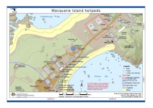
Map 14672: Macquarie Island helipads (Helicopter Operations)
Map details
| Map Number | 14672 |
| Title | Macquarie Island helipads (Helicopter Operations) |
| Edition | 2 |
| Previous edition | [Previous edition : 1] |
| Scale | 1 : 1500 |
| Publication date | July 2018 |
| Publisher |
Australian Antarctic Division (Australia)
|
| Spatial coverage |
(158.9342° -54.4983°)
,
(158.9403° -54.4983°)
,
(158.9403° -54.5003°)
(158.9342° -54.5003°) |
| Projection | Universal Transverse Mercator |
| Physical size | 21 x 29.7 cm A4 |
| Keywords | Helicopter , Parking |
Downloads
This is a digital map available for downloading.
Map Lists
This map belongs to the following lists. Use the link on the list to see all maps belonging to that list
Additional Information
| Horizontal datum | WGS84 |
| Vertical datum | Mean Sea Level |
| Vertical unit | Metres |
Preview