Map 14676: Macquarie Island: Buildings and Structures
Map details
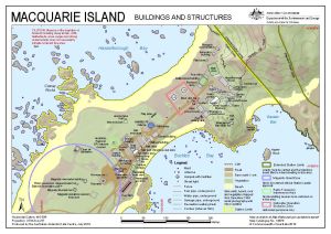
| Map Number | 14676 |
| Title | Macquarie Island: Buildings and Structures |
| Edition | 10 (Out of Date) |
| Previous edition | [Previous edition : 9] |
| Next Edition | [Next Edition : 11] |
| Scale | 1 : 2500 |
| Publication date | July 2018 |
| Publisher |
Australian Antarctic Division (Australia)
|
| Spatial coverage |
(158.9323° -54.4972°)
,
(158.9429° -54.4972°)
,
(158.9429° -54.5009°)
(158.9323° -54.5009°) |
| Projection | Universal Transverse Mercator |
| Physical size | 21 x 29.7 cm A4 |
| Notes |
© Commonwealth of Australia 2018 . |
| Keywords | Garden Bay , Hasselborough Bay , Cosray Rocks , Buckles Bay , Hayter Rock , Station |
Downloads
This is a digital map available for downloading.
Map Lists
No maps lists available.
Additional Information
| Horizontal datum | WGS84 |
| Vertical datum | Mean sea level |
| Vertical unit | Metres |
| Nomenclature | Nomenclature Board of Tasmania |
Preview