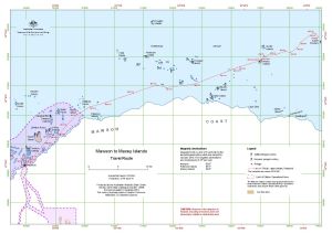
Map 14694: Mawson to Macey Islands
Travel Route
Map details
| Map Number | 14694 |
| Title | Mawson to Macey Islands Travel Route |
| Edition | 2 |
| Previous edition | [Previous edition : 1] |
| Scale | 1 : 135 000 |
| Publication date | January 2019 |
| Publisher |
Australian Antarctic Division (Australia)
|
| Spatial coverage |
( 62.8172° -67.3633°)
,
( 64.0658° -67.3633°)
,
( 64.0658° -67.6931°)
( 62.8172° -67.6931°) |
| Projection | Universal Transverse Mercator |
| Physical size | 29.7 x 42 cm A3 |
| Notes |
The topographic data is from the Antarctic Digital Database The adélie penguin colony locations are from: Southwell, C., Emmerson, L. (2017, updated 2017) Boundaries of Adelie penguin breeding colonies at numerous breeding sites across east Antarctica Australian Antarctic Data Centre - doi:10.4225/15/58f59b52edfef. |
| Keywords | Douglas Islands , Child Rocks , Anderson Island , Thorgaut Island , Macey Islands , Auster Rookery , Auster Islands , Robinson Group , Macklin Island , Kirton Island , Cape Daly , Safety Island , Landmark Point , Austskjera , Sawert Rocks , Hansen Rocks , Canopus Islands , Klung Islands , Smith Rocks , Kitney Island , Wiltshire Rocks , Paterson Islands , Welch Island , Jocelyn Islands , Topographic |
Downloads
This is a digital map available for downloading.
Map Lists
This map belongs to the following lists. Use the link on the list to see all maps belonging to that list
Additional Information
| Horizontal datum | WGS84 |
| Nomenclature | Australian Antarctic Gazetteer |
Preview