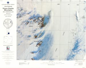
Map 14764: SR 41-42d Jetty Peninsula, Prince Charles Mountains, Mac. Robertson Land
Map details
| Map Number | 14764 |
| Title | SR 41-42d Jetty Peninsula, Prince Charles Mountains, Mac. Robertson Land |
| Edition | 2 |
| Previous edition | [Previous edition : 1] |
| Scale | 1 : 500 000 |
| Publication date | February 1993 |
| Publisher | - |
| Spatial coverage |
( 65.4783° -69.8833°)
,
( 72.8000° -69.8833°)
,
( 72.8000° -72.0031°)
( 65.4783° -72.0031°) |
| Projection | Lambert Conformal Conic |
| Physical size | 54 x 69 cm |
| Reference |
SR 41-42d Cat.No:M9 in 'ANARE Catalogue of Maps and Hydrographic Charts 1997' |
| Keywords | Jetty Peninsula , Prince Charles Mountains , Mac.Robertson Land , Athos Range , Dovers , Scylla Glacier , Porthos Range , Charybdis Glacier , Aramis Range , Nemesis Glacier , Soyuz , Jetty Peninsula , Amery Ice Shelf , Lambert Glacier , Gillock Island , Manning Nunataks , Fisher Massif , Sr41-42D , Satellite Imagery |
Downloads
This is a hard copy map that has been scanned. See information about obtaining copies of hard copy maps.
Map Lists
No maps lists available.
Additional Information
| Vertical unit | Metres |
| Nomenclature | Australian Antarctic Gazetteer |
Preview