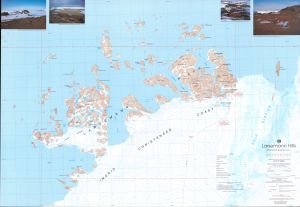
Map 15: Larsemann Hills / Princess Elizabeth Land
Map details
| Map Number | 15 |
| Title | Larsemann Hills / Princess Elizabeth Land |
| Edition | 1 |
| Scale | 1 : 25 000 |
| Publication date | March 1991 |
| Publisher |
Australian Antarctic Division (Australia)
|
| Spatial coverage |
( 75.9100° -69.3317°)
,
( 76.5583° -69.3317°)
,
( 76.5583° -69.4880°)
( 75.9100° -69.4880°) |
| Projection | Transverse Mercator |
| Physical size | 70 x 101 cm |
| Notes | This map was published as a double-sided map. This entry in the map catalogue refers to the edition 1 of the topographic map. Refer to Map No. 16 for the satellite image map, edition 2. |
| Reference | Cat. No: L15 in 'ANARE Catalogue of Maps and Hydrographic Charts 1997' |
| Keywords | Ingrid , Christensen , Stornes , Broknes , Osmar , Knuckey , Cook , Richardson , Sandercock , Solomon , Mcleod , Betts , Butler , Breadloaf , Harley , Manning , Lovering , Striped , Climbing , Wall , Fisher , Twin , Satellite Imagery |
Downloads
This is a hard copy map that has been scanned. See information about obtaining copies of hard copy maps.
- A print file (PDF)
- A zipped image of the topographic map for use in Oziexplorer
- A LZW compressed TIFF
Map Lists
This map belongs to the following lists. Use the link on the list to see all maps belonging to that list
Additional Information
| Horizontal datum | WGS84 |
| Magnetic variation | 76 degrees West |
Preview