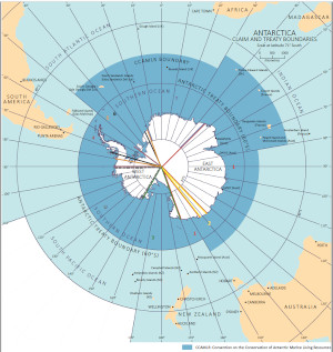
Map 15550: Antarctic Territorial Claim Boundaries
Map details
| Map Number | 15550 |
| Title | Antarctic Territorial Claim Boundaries |
| Edition | 1 |
| Scale | 1 : 80 000 000 |
| Publication date | July 2021 |
| Publisher |
Australian Antarctic Division (Australia)
|
| Spatial coverage |
(-180.0000° -30.0000°)
,
(180.0000° -30.0000°)
,
(180.0000° -90.0000°)
(-180.0000° -90.0000°) |
| Projection | WGS 1984 Antarctic Polar Stereographic |
| Physical size | 29.7 x 21 cm |
| Keywords | Territorial Claims |
Downloads
This is a digital map available for downloading.
Map Lists
This map belongs to the following lists. Use the link on the list to see all maps belonging to that list
Additional Information
Preview