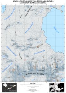
Map 15864: Bowles Ridge and Central Tangra Mountains
Map details
| Map Number | 15864 |
| Title | Bowles Ridge and Central Tangra Mountains |
| Edition | 1 |
| Scale | 1 : 25 000 |
| Publication date | March 2023 |
| Publisher |
Manfred Wörner Foundation (Bulgaria)
|
| Spatial coverage |
( -60.2803° -62.5342°)
,
( -60.0075° -62.5283°)
,
( -59.9917° -62.6839°)
( -60.2661° -62.6894°) |
| Projection | UTM zone 20S |
| Physical size | 86 x 59.5 cm |
| Notes | Data from the 2022 Reference Elevation Model of Antarctica (REMA), and 2004/05,2014/15 and 2016/17 Bulgarian topographic surveys. ISBN: 978-619-90008-6-1 License: CC BY-SA 4.0 |
| Alternative title | Livingston Island, Antarctica |
| Keywords | South Shetland Islands , Livingston Island , Varna Peninsula , Vidin Heights , Miziya Peak , Moon Bay , Kaliakra Glacier , Bowles Ridge , Atanasoff Nunatak , Burdick Peak , Perunika Glacier , Pliska Ridge , Camp Academia , Huron Glacier , Tangra Mountains , Mount Friesland , St. Boris Peak , Lyaskovets Peak , Great Needle Peak , Helmet Peak , Macy Glacier |
Downloads
- This hard copy English language map can be purchased from Librum.
- This is the digital Bulgarian version of the map available for download.
- This is the digital English version of the map available for download.
Map Lists
No maps lists available.
Additional Information
| Vertical datum | EGM2008 |
| Vertical unit | Metres |
| Nomenclature | SCAR Composite Gazetteer of Antarctica |
Preview