Map 15873: IEE Map 16: Mawson Station Wildlife
Map details
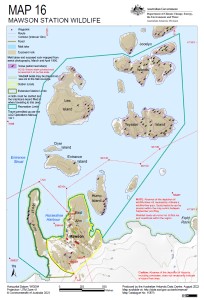
| Map Number | 15873 |
| Title | IEE Map 16: Mawson Station Wildlife |
| Edition | 1 |
| Scale | 1 : 11 500 |
| Publication date | 01 March 2024 |
| Publisher |
Australian Antarctic Division (Australia)
|
| Spatial coverage |
( 62.8572° -67.5819°)
,
( 62.9067° -67.5819°)
,
( 62.9067° -67.6074°)
( 62.8572° -67.6074°) |
| Projection | Universal Transverse Mercator |
| Physical size | 29.7 x 21 cm A4 |
| Notes |
© Commonwealth of Australia 2023 . The locations of snow petrel nest sites shown on this map are from a survey by Frederique Olivier as described by the metadata record 'A GIS dataset of Snow Petrel nests mapped in the Mawson region during the 2004-2005 season'. |
| Keywords | IEE , Mawson , Wildlife |
Downloads
This is a digital map available for downloading.
Map Lists
No maps lists available.
Additional Information
| Horizontal datum | WGS84 |
| Vertical datum | Mean sea level |
| Vertical unit | Metres |
Preview