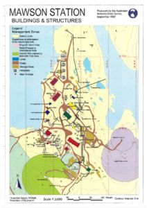
Map 15892: Mawson Station Buildings and Structures
Map details
| Map Number | 15892 |
| Title | Mawson Station Buildings and Structures |
| Edition | 2 (Out of Date) |
| Previous edition | [Previous edition : 1] |
| Next Edition | [Next Edition : 3] |
| Scale | 1 : 3000 |
| Publication date | September 1997 |
| Publisher |
Australian Antarctic Division (Australia)
|
| Spatial coverage |
( 62.8667° -67.5972°)
,
( 62.8833° -67.5972°)
,
( 62.8833° -67.6055°)
( 62.8667° -67.6055°) |
| Projection | UTM Zone 41 |
| Physical size | 29.7 x 21 cm A4 |
| Keywords | - |
Downloads
This is a hard copy map that has been scanned. See information about obtaining copies of hard copy maps.
Map Lists
No maps lists available.
Additional Information
| Vertical unit | Metres |
Preview