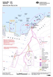
Map 15925: IEE Map 15: Mawson Region
Map details
| Map Number | 15925 |
| Title | IEE Map 15: Mawson Region |
| Edition | 1 |
| Scale | 1 : 200 000 |
| Publication date | March 2024 |
| Publisher |
Australian Antarctic Division (Australia)
|
| Spatial coverage |
( 62.3340° -67.4550°)
,
( 63.1900° -67.4550°)
,
( 63.1900° -67.9050°)
( 62.3340° -67.9050°) |
| Projection | WGS 1984 UTM Zone 41S |
| Physical size | - |
| Notes | © Commonwealth of Australia 2023 |
| Keywords | IEE , Mawson , Holme-Framnes |
Downloads
This is a hard copy map that has been scanned. See information about obtaining copies of hard copy maps.
Map Lists
No maps lists available.
Additional Information
| Horizontal datum | WGS84 |
| Vertical datum | MSL Mawson |
| Vertical unit | Feet |
| Nomenclature | Australian Antarctic Gazetteer |
Preview