Map 15978: Davis fixed-wing suggested flight path
Map details
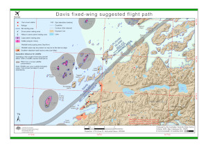
| Map Number | 15978 |
| Title | Davis fixed-wing suggested flight path |
| Edition | 3 |
| Previous edition | [Previous edition : 2] |
| Scale | 1 : 70 000 |
| Publication date | October 2023 |
| Publisher |
Australian Antarctic Division (Australia)
|
| Spatial coverage |
( 77.7907° -68.4968°)
,
( 78.2190° -68.4968°)
,
( 78.2190° -68.6075°)
( 77.7907° -68.6075°) |
| Projection | UTM Zone 43 |
| Physical size | 21 x 29.7 cm A4 |
| Keywords | Sea Ice Skiway , Magnetic Island , Turner Island , Bluff Island , Anchorage Island , Trigwell Island , Lugg Island , Flutter Island , Gardner Island , Warriner Island , Heidemann Bay , Suter Island , Torckler Rocks , Hobby Rocks , Lake Island , Barratt Island , Lucas Island , Zappert Point , Zvuchnyv Island , Partizan Island , Soldat Island , Powell Point , Broad Peninsula , Deep Lake , Lake Stinear , Lake Dingle |
Downloads
This is a digital map available for downloading.
Map Lists
This map belongs to the following lists. Use the link on the list to see all maps belonging to that list
Additional Information
| Horizontal datum | WGS84 |
| Vertical unit | Metres |
| Nomenclature | Australian Antarctic Gazetteer |
Preview