Map 16177: Aus 604 Southern Ocean - Macquarie Island and Approaches
Map details
| Map Number | 16177 |
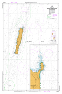
| Title | Aus 604 Southern Ocean - Macquarie Island and Approaches |
| Edition | 3 |
| Previous edition | [Previous edition : 2] |
| Scale | 1 : 100 000 |
| Publication date | 15 March 2024 |
| Publisher |
Hydrographic Service, Department of the Navy, Wollongong (Australia)
|
| Spatial coverage |
(159.5967° -54.2333°)
,
(158.5833° -54.2333°)
,
(158.5833° -55.1617°)
(159.5967° -55.1617°) |
| Projection | Mercator |
| Physical size | 110 x 73 cm |
| Notes | Inset of Hasselborough & Buckles Bay (1:15 000) |
| Reference | Aus 604 |
| Keywords | Aus604 , Hasselborough Bay , Buckles Bay , Chart , Nautical , Chart |
Downloads
Map Lists
This map belongs to the following lists. Use the link on the list to see all maps belonging to that list
Additional Information
| Horizontal datum | WGS84 |
Preview