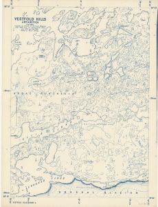
Map 1754: Vestfold Hills, Antarctica 1958 1:20,000 (Sheet 4)
Map details
| Map Number | 1754 |
| Title | Vestfold Hills, Antarctica 1958 1:20,000 (Sheet 4) |
| Edition | - |
| Scale | 1 : 20 000 |
| Publication date | June 1958 |
| Publisher |
Department of National Development, Division of National Mapping (Australia)
|
| Spatial coverage |
( 78.0000° -68.5000°)
,
( 78.3333° -68.5000°)
,
( 78.3333° -68.6667°)
( 78.0000° -68.6667°) |
| Projection | Not Given |
| Physical size | 102 x 82.5 cm |
| Notes |
Compiled from air photographs flown Jan. 1957 and Feb. 1958. Revised to March 1959. |
| Reference | S1/137 Sheet 4, Vestfold Hills Sheet 4 |
| Keywords | Vestfold Hills , Sorsdal Glacier , Broad Peninsula , Lake Dingle , Ellis Fjord , Lake Stinear , Weddell Arm , Lied Bluff , Camp Lake , Plough Island |
Downloads
This is a hard copy map that has been scanned. See information about obtaining copies of hard copy maps.
Map Lists
No maps lists available.
Additional Information
Preview