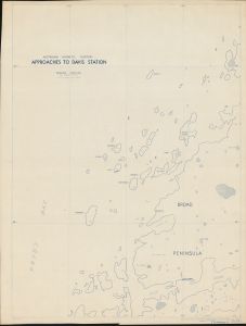
Map 1759: Approaches to Davis Station
Map details
| Map Number | 1759 |
| Title | Approaches to Davis Station |
| Edition | - |
| Scale | 1 : 20 000 |
| Publication date | October 1958 |
| Publisher |
Department of National Development, Division of National Mapping (Australia)
|
| Spatial coverage |
( 77.7500° -68.4667°)
,
( 78.0833° -68.4667°)
,
( 78.0833° -68.6333°)
( 77.7500° -68.6333°) |
| Projection | Mercator |
| Physical size | - |
| Notes | Showing Approaches |
| Reference | S1/81, NMP 58/117.3 |
| Keywords | - |
Downloads
This is a hard copy map that has been scanned. See information about obtaining copies of hard copy maps.
Map Lists
No maps lists available.
Additional Information
| Vertical unit | Metres |
Preview