Map 5131: Draft - Larsemann Hills
Map details
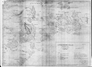
| Map Number | 5131 |
| Title | Draft - Larsemann Hills |
| Edition | - |
| Scale | 1 : 25 000 |
| Publication date | 1987 |
| Publisher |
Australian Antarctic Division (Australia)
|
| Spatial coverage |
( 75.9724° -69.3411°)
,
( 76.4667° -69.3411°)
,
( 76.4667° -69.4700°)
( 75.9724° -69.4700°) |
| Projection | Not Given |
| Physical size | 60 x 81 cm |
| Notes |
This map shows place names with some annotations (corrections). There is also an earlier version produced for the Australian Antarctic Names Committee showing approved names, proposed names and Norwegian names proposed to be adopted. Compilation and draft by Kurt Stuwe, Dept of Geology, Melbourne University. |
| Keywords | Stornes Peninsula , Broknes Peninsula , Vestodden Peninsula , Breadloaf Island , Dalkoy , Stuwe , Place Names , Survey Marks , Topographic |
Downloads
Map Lists
No maps lists available.
Additional Information
Preview