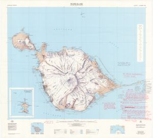
Map 5160: Heard Island 1986 Aerial Photography Flight Plan
Map details
| Map Number | 5160 |
| Title | Heard Island 1986 Aerial Photography Flight Plan |
| Edition | - |
| Scale | 1 : 50 000 |
| Publication date | 21 August 1987 |
| Publisher |
Australian Antarctic Division (Australia)
|
| Spatial coverage |
( 73.2333° -52.9000°)
,
( 73.8833° -52.9000°)
,
( 73.8833° -53.2167°)
( 73.2333° -53.2167°) |
| Projection | Universal Transverse Mercator |
| Physical size | 86.5 x 95 cm |
| Notes | Flight lines and notes hand written on published map (Heard Island including McDonald Islands Ed. 3 Dec 1985) |
| Reference | Prepared by Jenny Scott, 21 Aug 1987 |
| Keywords | Heard Island , flight lines , flight paths , run |
Downloads
Map Lists
No maps lists available.
Additional Information
Preview