Map 5169: Heard Island
Map details
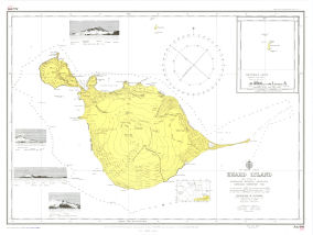
| Map Number | 5169 |
| Title | Heard Island |
| Edition | 1 |
| Scale | 1 : 83 000 |
| Publication date | December 1949 |
| Publisher |
Hydrographic Service, Department of the Navy, Wollongong (Australia)
|
| Spatial coverage |
( 73.1667° -52.9000°)
,
( 73.9833° -52.9000°)
,
( 73.9833° -53.2500°)
( 73.1667° -53.2500°) |
| Projection | Mercator |
| Physical size | 56 x 71.5 cm |
| Notes | Hydrographic Chart. Compiled from 1948 ANARE survey. Soundings in fathoms. Inset: McDonald Group (1:83000) at 53.033 S and 72.583 W. Earlier reference AUS 08 |
| Reference | Aus 606, Aus 08 |
| Keywords | Heard Island , Australian National Research Expedition 1948 , Aus606 , Aus 08 , Nautical |
Downloads
This is a hard copy map that has been scanned. See information about obtaining copies of hard copy maps.
- Image from scan (JPEG)
- Link to the Australian Hydrographic Office Index of Australian Paper Charts and chart purchasing.
Map Lists
No maps lists available.
Additional Information
| Accuracy | Not for Navigation. This chart is available for historical reasons. For the latest chart information, see |
Preview