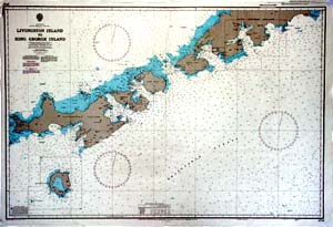
Map 5516: Livingston Island to King George Island (South Shetland Islands)
Map details
| Map Number | 5516 |
| Title | Livingston Island to King George Island (South Shetland Islands) |
| Edition | - |
| Scale | 1 : 200 000 |
| Publication date | 1968 |
| Publisher |
Hydrographic Department, Ministry of Defence (United Kingdom)
|
| Spatial coverage |
( -61.2667° -62.0000°)
,
( -57.5000° -62.0000°)
,
( -57.5000° -63.1333°)
( -61.2667° -63.1333°) |
| Projection | Mercator |
| Physical size | - |
| Notes | Hydrographic Charts. |
| Reference | 1776 |
| Keywords | Reference Number 1776 , Livingston Island To King George Island , South Shetland Islands |
Downloads
No downloads available.
This is a hard copy map. See information about obtaining copies of hard copy maps.
Map Lists
No maps lists available.
Additional Information
Preview