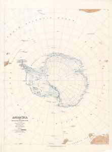
Map 5917: Antarctica with Subglacial and Ocean Bottom Features [set]
Map details
| Map Number | 5917 |
| Title | Antarctica with Subglacial and Ocean Bottom Features [set] |
| Edition | 1 |
| Scale | 1 : 10 000 000 |
| Publication date | 1962 |
| Publisher |
US Geological Survey (United States of America)
|
| Spatial coverage |
(-180.0000° -30.0000°)
,
(180.0000° -30.0000°)
,
(180.0000° -90.0000°)
(-180.0000° -90.0000°) |
| Projection | Azimuthal Equal Area Polar |
| Physical size | 114 x 86 cm |
| Notes | Printed on two sheets. These maps prepared from plates originally designed for a two layer, three dimensional plastic model. |
| Keywords | Byrd Subglacial Basin , Polar Subglacial Basin , Wilkes Subglacial Basin , Bentley Subglacial Trench , Pennell Bank , Iselin Bank , Fram Bank , Four Ladies Bank , Horlick Mountains |
Downloads
This is a hard copy map that has been scanned. See information about obtaining copies of hard copy maps.
Map Lists
No maps lists available.
Additional Information
| Nomenclature | U.S. Board on Geographic Names |
Preview