Map 912: Amundsen Bay to Vestfold Hills: Major Geological Journeys 1958
Map details
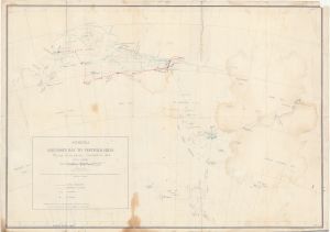
| Map Number | 912 |
| Title | Amundsen Bay to Vestfold Hills: Major Geological Journeys 1958 |
| Edition | 1 |
| Scale | 1 : 2 000 000 |
| Publication date | October 1958 |
| Publisher |
Australia
|
| Spatial coverage |
( 40.0000° -64.5000°)
,
( 84.5000° -64.5000°)
,
( 84.5000° -74.5000°)
( 40.0000° -74.5000°) |
| Projection | Polyconic |
| Physical size | 56 x 78 cm |
| Notes | Shows land journeys and aircraft flights to/from Mawson and Enderby Land and landings and astro fixes 1958. |
| Reference | ANARE Reports Series A, Vol. III : Geology. A contribution to the geology and glaciology of the western part of Australian Antarctic Territory by P.W. Crohn. Melbourne: Antarctic Division, Sept. 1959 |
| Keywords | Amundsen Bay , Vestfold Hills , Mawson , Enderby Land |
Downloads
This is a hard copy map that has been scanned. See information about obtaining copies of hard copy maps.
Map Lists
No maps lists available.
Additional Information
Preview