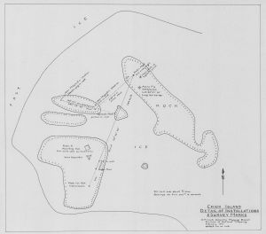
Map 991: Chick Island : detail of installations and survey marks
Map details
| Map Number | 991 |
| Title | Chick Island : detail of installations and survey marks |
| Edition | - |
| Scale | 1 : 480 |
| Publication date | 1961 |
| Publisher |
Department of National Development, Division of National Mapping (Australia)
|
| Spatial coverage |
(120.9875° -66.7886°)
,
(120.9906° -66.7886°)
,
(120.9906° -66.7900°)
(120.9875° -66.7900°) |
| Projection | Not Given |
| Physical size | 42.5 x 48 cm |
| Notes | Compiled by D.P. Cook |
| Keywords | Chick Island , D.P. Cook , Survey Marks , Sabrina Coast , Wilkes Land |
Downloads
This is a hard copy map that has been scanned. See information about obtaining copies of hard copy maps.
Map Lists
No maps lists available.
Additional Information
Preview