Gaz1 station information
Station identification
- Primary name
- Gaz1
Locality
No locality
Type
Heard Island Control
General
- Metadata
-
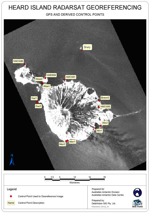
Heard_RadarSat_georef - Heard Island Radarsat Georeferencing Report, September 2002
- Date last visited
-
No visits or not recorded (if present then see metadata record)
- Date last maintained
- Location details
| Coordinates |
| Datum | Latitude | Longitude | Accuracy (m) | Order | Grid | Easting | Northing | Date released | Status |
| MSL |
-53° 4' 32.262600"
-53.07562851 |
73° 21' 44.478600"
73.36235516 |
|
|
43 |
390293.320 |
4118062.850 |
|
Current |
|
Orthometric
Heights |
| Datum | Height (m) | Accuracy (m) | Order | Date released | Status |
| MSL |
3.87 |
|
|
|
Current |
|
| Documents |
| Type | Name/Photo/Sketch thumbnail |
| Photo Identification |
View image
|
| Photo Identification |
View image
|
| Photo Identification |
View image
|
| Photo Identification |
View image
|
| Satellite Image |
No Image Available
Satellite Image Catalogue - View Reference 
Pixel on image - X=1840.0054 (residual 0.8804) Y=787.4431 (residual -0.6819)
|
| Satellite Image |
No Image Available
Satellite Image Catalogue - View Reference
Pixel on image - X=612.3962 (residual 1.2712) Y=1044.9411 (residual -1.4339)
|
| Satellite Image |
Satellite Image Catalogue - Image Id 1977 not in the Satellite Image Catalogue.
Pixel on image - X=819.6035 (residual 1.396) Y=-4096.14 (residual 0.855)
|
| Satellite Image |
Satellite Image Catalogue - Image Id 1978 not in the Satellite Image Catalogue.
Pixel on image - X=819.6035 (residual 1.396) Y=-4096.14 (residual 0.855)
|
|
There are no nearby stations within 0.25 degrees of this station.