Name details
Loewe Massif
Loewe Massif (The name as it would appear in a gazetteer)
Loewe Massif (The name as it would appear on a map)
If this information is incorrect, please e-mail mapping@aad.gov.au
Feature type: Massif (2c)
Origin
This name originates from United States of America. It is part of the United States Gazetteer and the SCAR Composite Gazetteer of Antarctica.
Names that other countries have for this feature:
- Loewe Massif (Australia)
- Loewe massif (Russia)
Narrative
A large rock massif in the E part of the Aramis Range, Prince Charles Mountains. The surface of the massif is largely an undulating plateau from which Mount Loewe and Medvecky Peaks rise. The plateau lies at an average elevation of 1,000 m above the sea level and 600 m above the ice on its northern flank. Discovered by an ANARE party led by W.G. Bewsher in 1956. The name of the massif derives from Mount Loewe, which was named for Fritz Loewe, a member of the ANARE reconnaissance party in the French expedition at Port Martin, Adelie Coast, in 1951.
Named For
Location
Images
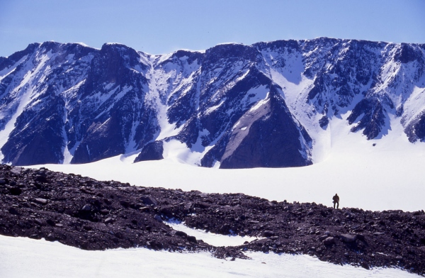
©Adrian Corvino 2004
- Catalogue id
- IA16518
- Caption
- View of south facing slope of L¿ewe Massif where it abuts the MCkinnon Glacier. Photo taken from ground control point referred to as BL14 in the 2003/04 survey report. BL14 is at latitude 70¿38'01" south and longitdue 67¿ 38' 06" east.
- Photographer
- Corvino, Adrian
Map
Source
Comments
NoneApproval status
Display Scales
For example, selecting 'Aus_display_scale_20M' would only return names that would appear on a 1:20 million scale map.
| Aus_display_scale_20M: | No | Aus_display_scale_10M: | No | ||
| Aus_display_scale_5M: | No | Aus_display_scale_2M: | No | ||
| Aus_display_scale_1M: | No | Aus_display_scale_500k: | No | ||
| Aus_display_scale_250k: | No | Aus_display_scale_100k: | No | ||
| Aus_display_scale_50k: | No | Aus_display_scale_25k: | No | ||
| Aus_display_scale_10k: | No | Aus_display_scale_5k: | No | ||
| Aus_display_scale_1k: | No |
Related information
Biodiversity
View
fauna,
flora or
both
within 1.0 degree of this location
Place names
View
American or
international
place names within 1.0 degree of this location.