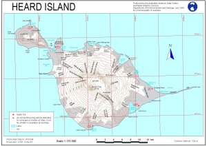
Map 11253: Heard Island
Map details
| Map Number | 11253 |
| Title | Heard Island |
| Edition | 1 |
| Scale | 1 : 170 000 |
| Publication date | July 1999 |
| Publisher |
Australian Antarctic Division (Australia)
|
| Spatial coverage |
( 73.1667° -52.9167°)
,
( 73.9167° -52.9167°)
,
( 73.9167° -53.2500°)
( 73.1667° -53.2500°) |
| Projection | Universal Transverse Mercator |
| Physical size | 21 x 29.7 cm A4 |
| Notes | A 1:200000 version of this map will be published in "Papers and Proceedings of the Royal Society of Tasmania Volume 133 Part II, Heard Island Papers" |
| Keywords | Topographic |
Downloads
This is a digital map available for downloading.
Map Lists
This map belongs to the following lists. Use the link on the list to see all maps belonging to that list
Additional Information
Preview