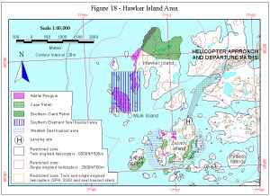
Map 11382: Figure 18 - Hawker Island Area Helicopter Operations
Map details
| Map Number | 11382 |
| Title | Figure 18 - Hawker Island Area Helicopter Operations |
| Edition | 1 (Out of Date) |
| Next Edition | [Next Edition : 2] |
| Scale | 1 : 60 000 |
| Publication date | June 1999 |
| Publisher |
Australian Antarctic Division (Australia)
|
| Spatial coverage |
( 77.7330° -68.6170°)
,
( 77.9330° -68.6170°)
,
( 77.9330° -68.6830°)
( 77.7330° -68.6830°) |
| Projection | Universal Transverse Mercator |
| Physical size | 70 x 90 cm |
| Notes | Used in the publication "Environmental Guidelines for Antarctic and Subantarctic Helicopter Operations". Edition 1 of the maps, November 1999 |
| Keywords | - |
Downloads
This is a digital map available for downloading.
Map Lists
No maps lists available.
Additional Information
Preview