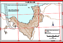
Map 12580: Scullin Monolith : Helicopter approach and departure path
Map details
| Map Number | 12580 |
| Title | Scullin Monolith : Helicopter approach and departure path |
| Edition | 2 (Out of Date) |
| Previous edition | [Previous edition : 1] |
| Next Edition | [Next Edition : 3] |
| Scale | 1 : 15 800 |
| Publication date | August 2000 |
| Publisher |
Australian Antarctic Division (Australia)
|
| Spatial coverage |
( 66.6830° -67.7778°)
,
( 66.7670° -67.7778°)
,
( 66.7670° -67.8000°)
( 66.6830° -67.8000°) |
| Projection | Universal Transverse Mercator |
| Physical size | 21 x 29.7 cm A4 |
| Notes | Used in the publication "Flight paths for helicopter operations in Australian Antarctic Territory". Edition 2 of the maps, August 2000. Flying in the area covered by this map requires a permit |
| Keywords | Scullin Monolith , Helicopter Operations |
Downloads
This is a digital map available for downloading.
Map Lists
No maps lists available.
Additional Information
| Nomenclature | Australian Antarctic Gazetteer |
Preview