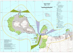
Map 12680: Heard Island Map 1 of 5
Map details
| Map Number | 12680 |
| Title | Heard Island Map 1 of 5 |
| Edition | 2 |
| Previous edition | [Previous edition : 1] |
| Scale | 1 : 50 000 |
| Publication date | December 2000 |
| Publisher |
Australian Antarctic Division (Australia)
|
| Spatial coverage |
( 73.2200° -52.9300°)
,
( 73.5300° -52.9300°)
,
( 73.5300° -53.0700°)
( 73.2200° -53.0700°) |
| Projection | Universal Transverse Mercator |
| Physical size | 29.7 x 42 cm A3 |
| Keywords | Heard Island , Laurens Peninsula , Azorella Peninsula , Anzac Peak , Red Island , Rogers Head , Corinth Head , The Nullabor , Desperation Gully , Saddle Point , Hoseason Beach , Corinthian Bay , Topographic |
Downloads
This is a digital map available for downloading.
Map Lists
This map belongs to the following lists. Use the link on the list to see all maps belonging to that list
Additional Information
| Horizontal datum | WGS84 |
| Vertical datum | msl |
| Nomenclature | Australian Antarctic Names Gazetteer |
Preview