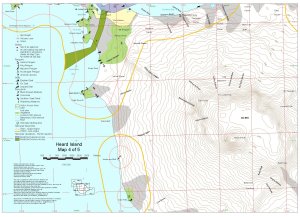
Map 12683: Heard Island Map 4 of 5
Map details
| Map Number | 12683 |
| Title | Heard Island Map 4 of 5 |
| Edition | 2 |
| Previous edition | [Previous edition : 1] |
| Scale | 1 : 50 000 |
| Publication date | December 2000 |
| Publisher |
Australian Antarctic Division (Australia)
|
| Spatial coverage |
( 73.2700° -53.0000°)
,
( 73.5800° -53.0000°)
,
( 73.5800° -53.1700°)
( 73.2700° -53.1700°) |
| Projection | Universal Transverse Mercator |
| Physical size | 29.7 x 42 cm A3 |
| Keywords | Heard Island , Big Ben , Mawson Peak , Desperation Gully , Challenger Glacier , Chittleborough Ridge , Mary Powell Glacier , Lied Glacier , Cape Pillar , Henderson Bluff , Walsh Bluff , Pulpit Rock , Cape Gazert , Erratic Point , Pageos Moraine , Walrus Beach , The Nullabor , Oriental Island , Veenstra Peak , Mount Drygalski , Mangoro Head , West Bay , Cave Bay , Fremantle Peak , Davis Dome , Campbell Peak , Budd Peak , Topographic |
Downloads
This is a digital map available for downloading.
Map Lists
This map belongs to the following lists. Use the link on the list to see all maps belonging to that list
Additional Information
| Horizontal datum | WGS84 |
| Vertical datum | msl |
| Nomenclature | Australian Antarctic Names Gazetteer |
Preview