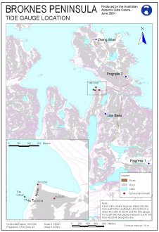
Map 12712: Broknes Peninsula Tide Gauge Location
Map details
| Map Number | 12712 |
| Title | Broknes Peninsula Tide Gauge Location |
| Edition | 1 |
| Scale | 1 : 20 000 |
| Publication date | June 2001 |
| Publisher |
Australian Antarctic Division (Australia)
|
| Spatial coverage |
( 76.3167° -69.3667°)
,
( 76.4083° -69.3667°)
,
( 76.4083° -69.4111°)
( 76.3167° -69.4111°) |
| Projection | Universal Transverse Mercator |
| Physical size | 29.7 x 21 cm A4 |
| Notes | Since this map was produced the tide gauge has been removed. The tide gauge mooring remains at the site. |
| Keywords | Survey Marks |
Downloads
This is a digital map available for downloading.
Map Lists
No maps lists available.
Additional Information
Preview