Map 12755: Cape Denison - George V Land Coast
Map details
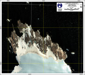
| Map Number | 12755 |
| Title | Cape Denison - George V Land Coast |
| Edition | 1 |
| Scale | 1 : 5000 |
| Publication date | December 2001 |
| Publisher |
Australian Antarctic Division (Australia)
|
| Spatial coverage |
(142.6486° -66.9986°)
,
(142.7006° -66.9986°)
,
(142.7006° -67.0175°)
(142.6486° -67.0175°) |
| Projection | Universal Transverse Mercator |
| Physical size | 46 x 51 cm |
| Notes | Map produced from georeferenced Ikonos satellite imagery, dated 2001-01-26 and 2001-01-31. |
| Keywords | Cape Denison , Ikonos , High Resolution , Satellite Imagery , Commonwealth Bay , Geo Reference , Coast , Satellite Imagery |
Downloads
This is a digital map available for downloading.
Map Lists
This map belongs to the following lists. Use the link on the list to see all maps belonging to that list
Additional Information
| Accuracy | Relative - 1 metre, Absolute 25 metres |
| Horizontal datum | WGS 84 |
| Vertical datum | N/A |
Preview