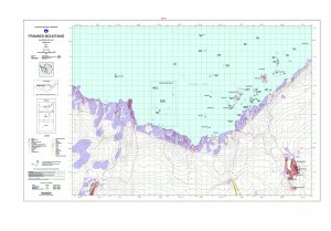
Map 12920: Draft - Framnes Mountains, MacRobertson Land, Antarctica. Sheet 1
Map details
| Map Number | 12920 |
| Title | Draft - Framnes Mountains, MacRobertson Land, Antarctica. Sheet 1 |
| Edition | 1 (Out of Date) |
| Next Edition | [Next Edition : 2] |
| Scale | 1 : 50 000 |
| Publication date | January 2002 |
| Publisher |
Australian Antarctic Division (Australia)
|
| Spatial coverage |
( 62.1333° -67.4500°)
,
( 63.1333° -67.4500°)
,
( 63.1333° -67.7500°)
( 62.1333° -67.7500°) |
| Projection | Transverse Mercator |
| Physical size | 64.5 x 106 cm |
| Notes | This edition supersedes the preliminary map. |
| Keywords | Framnes Mountains , Casey Range , Mawson Station , Forbes Glacier , Spa 2 , Mount Henderson , Fischer Nunatak , Goldsworthy Ridge , Holme Bay , Topographic |
Downloads
This is a digital map available for downloading.
- A print file (PDF)
- An EPS file, gzipped
- A zipped image (TIF) for use in Oziexplorer
- A zipped image (TIF) of maps 12920, 12918, 12919 for use in Oziexplorer
Map Lists
No maps lists available.
Additional Information
| Horizontal datum | WGS84 |
| Vertical datum | Mean sea level |
| Magnetic variation | 66 deg. west of north |
Preview